
Man, stepping onto that buzzing stretch of Las Vegas Boulevard for the first time? It’s like diving into a whirlwind of flashing lights, endless crowds, and pure energy. But let’s be real, with over four miles packed with resorts, wild shows, and all sorts of distractions, it’s easy to get turned around. That’s where a solid Las Vegas Strip map comes in clutch. It lets you chart your course, catch those must-see spots, and make the most of every minute in this crazy town.
A Las Vegas Strip map is like your personal sidekick. Whether you’re hunting for fancy hotels or just want to hit up free stuff like dancing fountains, knowing the layout turns chaos into adventure. No more wandering in circles – you get straight to the good stuff.
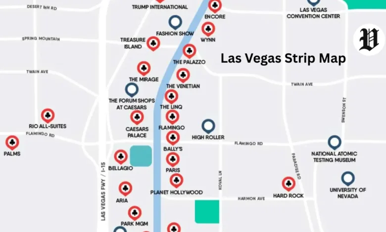
So, What’s the Deal with the Las Vegas Strip Anyway?
The Las Vegas Strip runs about 4.2 miles down Las Vegas Boulevard South. It’s technically in Clark County, Nevada, outside the actual city of Las Vegas. This iconic road pulls in crowds from everywhere for its casinos, killer entertainment, and nonstop nightlife.
The boundaries are pretty straightforward. It kicks off up north at Sahara Avenue, though folks sometimes stretch it to include the Strat with its insane views from the top. Down south, it wraps up around Russell Road, right by that classic “Welcome to Fabulous Las Vegas” sign. Grab a detailed Las Vegas Strip map to get a clear picture and plan your moves.
Traffic hums along, but the real action’s on the sidewalks where pedestrians own the scene. You’ve got overhead walkways, free trams, and the monorail to zip around. A handy Vegas Strip map points out all these shortcuts so you don’t waste time.
Breaking Down the Layout: North, Center, and South Vibes
I like to think of the Strip in three chunks – it makes everything less overwhelming. North has that blend of old-school charm and fresh spots, the center’s where the heart-pounding action is, and south feels a bit more laid-back with big luxuries. A map of the Vegas Strip ties it all together smoothly.
Kick things off in the north near Sahara. You’ll spot some up-and-coming places mixed with longtime favorites. Head south, and things ramp up with huge resorts and event spots. By the time you hit the southern end, it’s perfect for chilling out.
Walking’s the way to go if you want to soak it in, but distances add up quick. Covering north to south? That’s roughly 90 minutes if you’re hustling, way longer with pit stops for snaps. Look up Las Vegas Strip directions or use an app for on-the-spot advice.
The Big Hotels on the Strip: North-to-South Rundown
Hotels are what make the Strip tick. Each one’s got its own flair – think fake Paris streets or beachy pools. Use this Las Vegas Strip hotels map breakdown to choose your home base. Location’s key; smack in the middle means less trekking.
Check out this table of major spots from north to south, with standout perks and rough walk times:
| Hotel Name | Position on Strip | Key Features | Walking Time from North End |
| Strat | Far North | Sky-high tower, adrenaline rides | Starting point |
| Sahara Las Vegas | North | Vintage feel, killer infinity pool | 5-10 minutes south |
| Fontainebleau Las Vegas | North | Sleek modern vibes, fresh since 2023 | 10-15 minutes south |
| Resorts World | North | Techy rooms, eats from around the world | 15-20 minutes south |
| Circus Circus | North | Kid stuff galore, inside theme park | 20-25 minutes south |
| Treasure Island | Center | Pirate battles, right in the thick of it | 30-35 minutes south |
| Venetian / Palazzo | Center | Canal rides, upscale shops | 35-40 minutes south |
| Wynn / Encore | Center | Gorgeous gardens, top-notch grub | 40-45 minutes south |
| Harrah’s | Center | Fun carnival energy, easy on the wallet | 45-50 minutes south |
| Linq | Center | Giant wheel views, street food scene | 50-55 minutes south |
| Flamingo | Center | Animal gardens, old Vegas history | 55-60 minutes south |
| Caesars Palace | Center | Roman empire theme, epic shopping | 60-65 minutes south |
| Bellagio | Center | Those famous water shows, art exhibits | 65-70 minutes south |
| Paris | Center | Eiffel Tower knockoff, French bites | 70-75 minutes south |
| Planet Hollywood | Center | Star-struck atmosphere, attached mall | 75-80 minutes south |
| Cosmopolitan | Center | Trendy pools, buzzing nights | 80-85 minutes south |
| Aria | South | High-tech everything, CityCenter core | 85-90 minutes south |
| Park MGM | South | Cozy bar vibes, chill hangs | 90-95 minutes south |
| New York-New York | South | Coaster thrills, NYC energy | 95-100 minutes south |
| MGM Grand | South | Huge venue for fights and concerts | 100-105 minutes south |
| Excalibur | South | Castle theme, affordable stays | 105-110 minutes south |
| Luxor | South | Pyramid with the beam, mysterious feel | 110-115 minutes south |
| Mandalay Bay | South | Aquarium adventures, wave pool | End point, 115+ minutes |
This map of hotels on the Las Vegas Strip setup helps weigh your choices. Say you’re into live performances – go central by Caesars. Got kids? Circus Circus is a no-brainer with all the fun inside.
Can’t-Miss Attractions Scattered Along the Way
The attractions are what crank up the excitement on the Strip. A Las Vegas Strip attractions map flags the freebies and ticketed gems. They’re sprinkled among the hotels, so you won’t miss ’em.
Don’t skip the Bellagio Fountains – water shooting up to tunes every 15-30 minutes. Right around there, the High Roller gives you bird’s-eye looks from way up. And the Sphere? That giant ball’s been blowing minds with its wraparound shows since 2023.
Down south, T-Mobile Arena packs in sports and big acts. Link these up on a detailed map of Las Vegas Strip attractions. Like, combine a gondola at the Venetian with a Sphere event for an awesome day out.
Shopping’s huge too. The Forum Shops at Caesars feel like stepping back to Rome, and Miracle Mile over at Planet Hollywood has all the latest trends. An aerial map of Vegas shows how it all fits together.
Fresh Scoop: What’s Shaking on the Las Vegas Strip in 2025?
The Strip never sits still. Back in 2024, we said goodbye to the Tropicana – it’s gone now, making room for a new Bally’s spot and even a baseball stadium by 2028. The Mirage closed up shop too, gearing up to flip into Hard Rock by 2027.
This year in 2025, things like XS Nightclub at Wynn are shutting temporarily for a big makeover. Flamingo’s got new eats popping up, and the Vegas Loop’s expanding those underground rides. Fontainebleau’s still the hot new kid on the block. A Las Vegas Strip map 2025 catches all these tweaks, including spots like the revamped BLVD shopping area.
Keep an eye on events – Cardi B’s tour hits town, and Bellagio’s fall display is stunning as ever. The Strip’s feeling a bit of a pinch economically, but that means deals for you. Dive into our Vegas updates post for more dirt.
How to Get Around: Tips for Walking and Riding
Foot power’s my favorite way to experience it, but you’ve got backups. The monorail zips from Sahara down to MGM, stopping at seven places. Those free trams link up like Bellagio to Aria without breaking a sweat.
Uber and such are everywhere, but watch for gridlock. The Deuce bus is cheap and runs all night. A Vegas Strip layout map marks monorail stops and tram routes crystal clear.
Those walks can sneak up on you – full north-south haul’s over two hours with breaks. Pack comfy kicks, grab water, and hit the skybridges to dodge traffic. A printable walking map of Las Vegas Strip slips right into your bag for no-data days.
Grab a Printable or Interactive Map for Your Adventure
Snag a printable map of Las Vegas Strip from spots like Vegas Unzipped or similar sites. They lay out hotels, sights, and even estimated stroll times. PDFs are gold for offline plotting.
Go interactive if you want to poke around – zoom in, tap for details. Some have bars and clubs highlighted. A Las Vegas Strip map PDF keeps you on track, signal or no.
Team it with apps for live buzz. You’ll snag specials or shows on the fly. Check our piece on must-have Vegas apps for extras.
Smart planning pays off big on the Strip. You jump into the thrill without the hassle. Chasing wins or just sightseeing, your map of the Strip in Las Vegas opens the doors wide.
FAQs
What is the Las Vegas Strip map?
The Las Vegas Strip map sketches out the 4.2-mile run of Las Vegas Boulevard South, marking hotels, attractions, and rides from Sahara north to Russell south. It guides you through places like Bellagio and Mandalay Bay without a hitch.
Where can I find a map of the Vegas Strip hotels?
A map of the Vegas Strip hotels runs down spots from north to south, like Wynn, Caesars Palace, and MGM Grand. Print ones from trusted spots make great trip companions.
How long is the Las Vegas Strip?
The Las Vegas Strip clocks in at 4.2 miles. Hustling end to end? About 90 minutes straight, but add time for detours on a detailed Las Vegas Strip map.
What does a Las Vegas Strip hotel map 2025 include?
A Las Vegas Strip hotel map 2025 spotlights fresh stuff like Fontainebleau and the Tropicana’s absence. It pins hotels from Resorts World north to Luxor south.
Where is the Las Vegas Strip located?
The Las Vegas Strip location hugs Las Vegas Boulevard South in Clark County, Nevada, beyond city lines. A map of Las Vegas NV shows how it sits near downtown and the airport.
What are the best attractions on the map of Las Vegas Strip attractions?
Top picks on a map of Las Vegas Strip attractions cover Bellagio Fountains, High Roller, and Sphere. They’re bunched in the center, close to hotels for easy hits.
How do I get a printable map of the Las Vegas Strip?
Score a printable map of the Las Vegas Strip via PDFs with hotels and monorail info. Perfect for roaming the Vegas Strip map offline.
What recent changes are on the Las Vegas Strip map 2024?
The Las Vegas Strip map 2024 flagged Mirage’s close and Tropicana’s demo. Updated maps steer you clear of build sites.
Where can I see a map of hotels on the Las Vegas Strip?
A map of hotels on the Las Vegas Strip highlights Paris, Planet Hollywood, and more. Interactive ones figure out walks between them.
What is the layout of the Las Vegas Strip?
The Las Vegas Strip layout flows north-south, packing more in the middle. A Vegas Strip layout map splits it into zones for smarter plans.